FS9/FSX. I am at a loss of words. Which, point in fact is not a good thing when it comes to
writing a review expressing my impression which, well... you know... requires words. A lot of words. Because my impression here is just about as big as the product itself. And this scenery is indeed, BIG. Thus I must gather my words carefully and arrange them in an order that not only makes sense, but gives an accurate description of what this product delivers, while expressing my
feelings about it.
This is FranceVFR's Haute Normandie VFR! Here we go!
BANDWIDTH WARNING: Lots of pictures enclosed.
Now the guys over at FranceVFR have been quite busy indeed developing new technologies for FSX. In fact, I would even go as far as to say they have pioneered the technology that has brought us these massive landscapes in high detail over the last few years. Where I find them to be downright stingy, however, is the fact that they directly limit their genius works to France and its territories. If F-VFR were to say, expand this technology in a way that Ground Environment and Ultimate Terrain does for us by covering areas as large as continents, there would be little use for the latter 2 products and we would have something a thousand times - heck, ten thousand times - better.

Now I can't say too much about what 3D automation is other than the fact that they have somehow, created a way to force the flight simulator to automatically render the autogen on a scale that is probably at least 10 times of what it was designed for. However they have managed to do this, all I can say is it's incredible. And that is putting my thoughts lightly.
Where I am also happy is they have decided to give a go with new technology and apply it to FS9. The result? Magnificent! I say this all the time, FS9 is my muscle car that I tend to drive more often than that Maserati I call FSX. The fact that not only can FS9 handle the load, there was absloutely NO change in FPS flying into it from the default landscape. That is simply incredible. Other developers keep saying the reason why they don't back-port their sceneries to FS9 is due to the limitation of the photosceneries and such. Well, I say, not anymore.
Now, keep in mind, all these screens were taken out of FS9. If you compare them to the
FSX shots on the FranceVFR website, you will find there is very little to no difference.
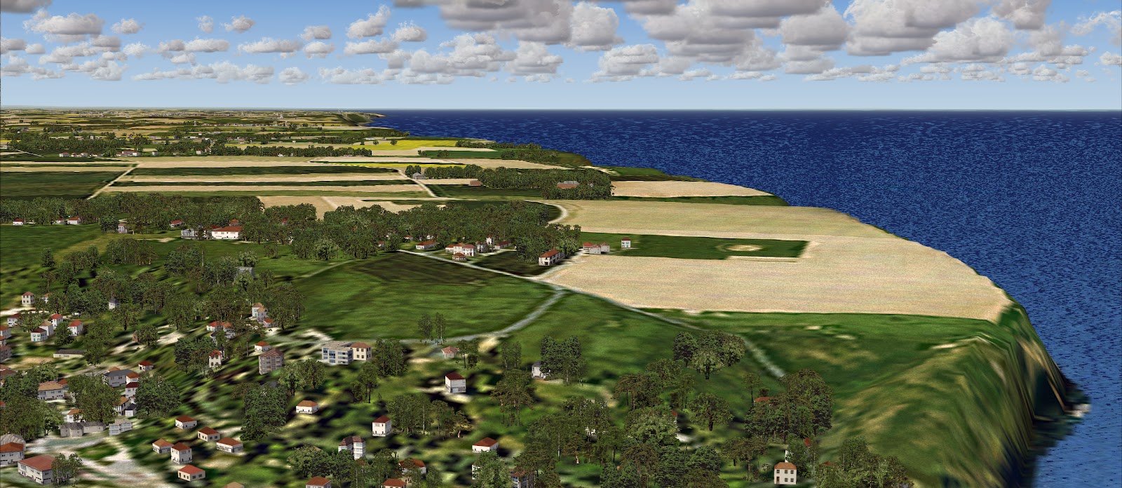
Have a look at the aerial shot I made. It's the same as the one found at the very top.
Now what this looks like is a simple photo scenery right?
Now have a look at the Google Earth image. I tried to match the two as closely as possible.
Now have another look at the first picture more closely. You are not simply looking at a photo layer. Every representation of a house or building you see in the picture is an actual building present in the scenery. Not, I repeat, NOT images of buildings!! This is autogen on a scale like I have never seen before! And when you are flying over it, the simulator generates ALL of it. The result is when you are flying around, the autogen buildings and trees expand all the way to the horizon. How in the hell did they do this?? With having NO effect on my system's performance? How?
That's a LOT OF AUTOGEN!!
The other thing I want to point out here is the quality of this custom made autogen. It was all done very stylishly and not at all rushed. The thought that us pilots would simply fly over it without really looking closely was not a thought the scientists over at FranceVFR had floating in their heads. They clearly took the time to make sure these cities were done right while looking damn good too. Oh, and accurate.
Which brings me on to my next point. Accuracy. Remember the first screenshot? And how the autogen appears to be all in the correct locations? Well, unlike default Autogen, these autogen scenery objects and cities do not at all appear to be random. It's as if they know exactly where to be and they just seem to go there. And we are talking several cities, towns, and villages all appearing exactly where they should. So no matter if you are just 700ft above in a Beechcraft or descending into CDG from the north at ten thousand feet, everything is exactly where they should be.
But it doesn't stop there. The scenery encompasses more. So much more to the point that you really have to explore the large scenery area, every inch of it just to see all it has to offer. All the landmarks are there. But that's not all...
This is funny!! Did these little boats really make their way from Seattle Washington? That must be a cookie!! The question is what does this mean? What does that boat represent? Like I said, every inch to explore!
Another thing I liked here are the power stations, all accurately placed and so realistic. The balls on the power lines to keep you from flying into them? I see this on my road trips here in California.
A nice fjord dropping into the ocean just like the actual place.
Now mind you, these are all townships accurately generated in this region. I dunno what all these towns are called. There's millions of them all over France. I have been to a few myself. It all just works so well in the virtual world.
See those wind farms up there. Yes, they are animated.
All the autogen trees and buildings are such an eyefull.
Another shot of the wind-farms with the town in the background.
There are many inlets with marinas like this among the coastal cities. No detail was left out here. What a joy to fly around.
Another random French coastal town teaming with autogen.
Here we see a much larger area. The autogen just seems to go on, and on. Amazing!! And highly realistic.
Very, very dense towns. How far does it go??
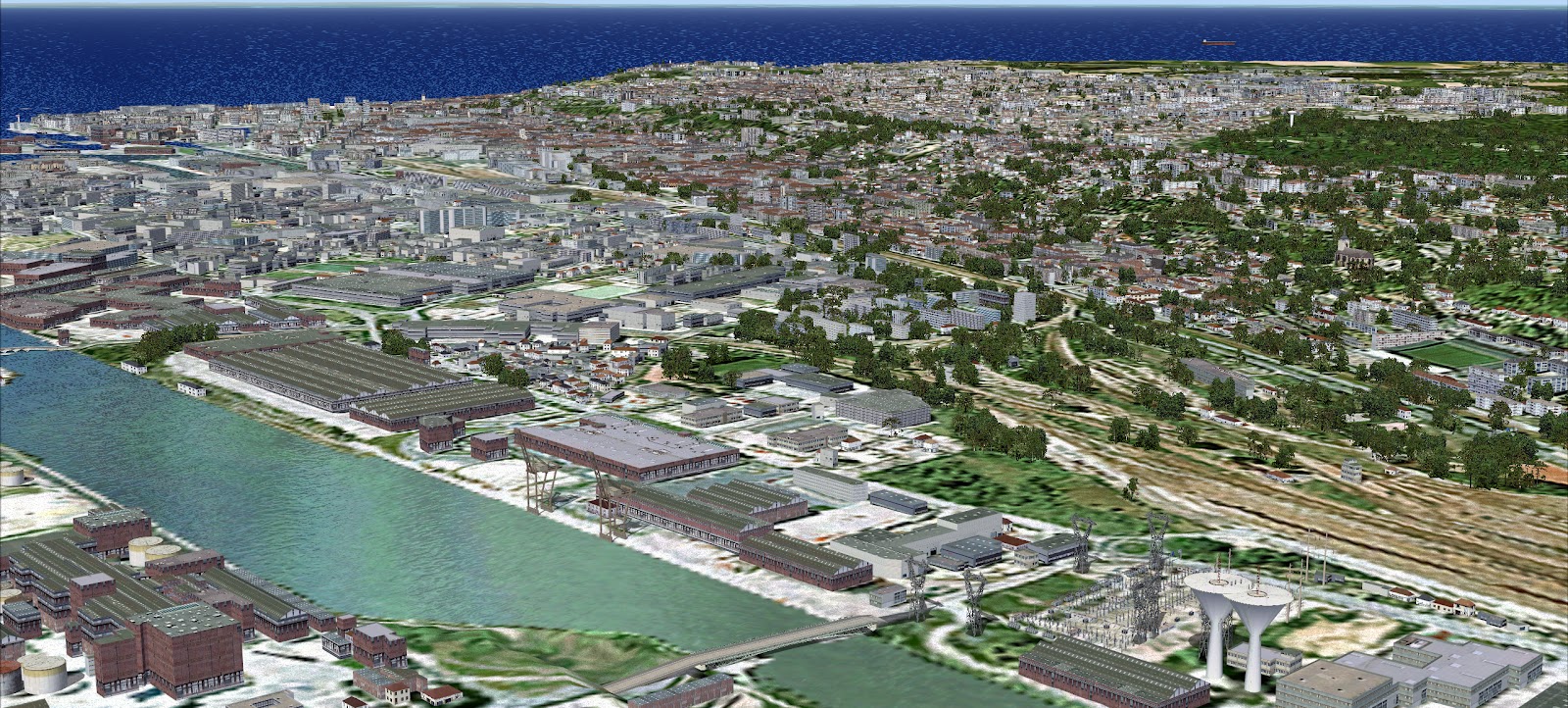
Now I mentioned this product had so much to offer. This area is complete with boats, cruise liners, and cargo ships. Even the detail on the ships is impressive!! Doesn't that look good?? There are several of these found within the Crique de Rouen.
An aerial shot of Crique de Rouen and so much autogen, I couldn't fit it all into the picture. This area was done so realistically rendered if you compared it to a Google Earth image, you would find very little difference.
Another random township teaming with autogen.
All bridges are accurately rendered and placed just where they should be.
Here is a shot where the autogen goes all the way to the horizon. How is this possible??
The cruise liners I mentioned earlier. Well detailed.
The highest density of autogen will be found in the city of Rouen which is no doubt the focal-point of this entire masterpiece. The southern edge of Houte Normandie also flows into the Flight Paris scenery area as well.
I really loved the look of this particular town. I had to add it in!
And my last 2 shots of Rouen. I HAD TO STOP HERE!!! There is just so much more in this product to show and at some point, I just had to stop!! It is all so beautiful, so perfect! So MUCH!! And worth the price! There is only one negative thing I have to say about this product. The included airports.
All in all there are 12 airports and airfields in the scenery area. The grass airfields were what anyone would expect. But the airports don't even live up to the previous airports FranceVFR used to make. They are down right horrible! If they could take so much time in creating everything down to the boats, why-oh-why not put some of this passion into the airports? Most are just afcads. This is the only thing FranceVFR did wrong with this work. What good is it to fly around this masterpiece only to land at a poorly barely put together airport?
Besides this I am happy which leaves the question. Do I like the product? Well... in a word..
NO!
Why?? Because at some point this scenery ends and default begins again. I don't want to fly around default anymore where 90% of my other airports around the world are. I want this scenery everywhere!! I don't want it to end!! It has brought yet another upgrade to my muscle car that is only limited to such a large yet small area. I want more! So much more! Thus all I can do is sit back and wait for the next 3D automation products to arrive. And hope, some day, they will expand out of the French territories.
While including some decent AIRPORTS!
This is a must have for everyone! 2 thumbs up!
Now that I found the words I was looking for, time to stop this blogging business and do what I love to do most at my computer.
FLY!
Cheers!
D'Andre Newman
((-D')) AirDailyX - we're on facebook! Join us!!


8 comments:
Two words, 'licence it'.....
One word, 'agreed!!'
I don't think Orbx will like it.... they are planning on taking over the world... literally..LOL. And this method France vfr has made will change the way vfr scenery is made completely if they license it.
I don't much care if Orbx don't like it, the more competition in the market the better for us simmers :) Personally I love the detailed nature of Orbx airport scenery but I prefer to fly over a real landscape and that means photoscenery. For me the ideal blend would be photo scenery across the world with autogen a la France VFR, with airfields designed to be compatible by the likes of Orbx. Sadly, I suspect that it will come down to a choice of one or the other, as Orbx will probably make their airfield scenery incompatible with photo scenery to try to protect their landclass ground scenery :(
And I honestly tend to spend more money on 9 than X which leaves me with so few Orbix products. I love Orbix. I think they have the most highly detailed scenery out there, but I am just not spending money on FSX. The fact that FranceVFR could do this means other developers can as well. It's all down to a matter of choice. Not ability.
((-D'))
Sorry, no magic at work here. We already talked to FranceVFR about licensing this tech but it is based on government data on building locations, not on photoimagery. This means unless there is data, you cannot generate autogen. I hate to burst your bubbles, sorry.
Great use of data though, it looks very nice indeed!
We are using another approach for our UK projects which goes to the next step beyond this. Stay tuned :)
OOOhhh! I'm very interested!! Backport a couple for my birthday John???
LOL!
Cheers!
((-D'))
Hmm, very interesting John, I consider myself appropriately teased!
Earth Simulations were looking at something like this over 18 months ago for the uk (http://www.earthsimulations.com/Forum/viewtopic.php?f=9&t=900&hilit=autogenesis) and have used similar vector data I think to produce their Treescapes product already.
I can't believe the French have a monopoly on good building location data either! (they don't, see Ordnance Survey's Mastermap info - http://www.ordnancesurvey.co.uk/oswebsite/products/os-mastermap/index.html ).
I remember Arno Gerretsen has looked at producing building autogen via openstreetmap last year as well... (http://msmvps.com/blogs/arnogerretsen/archive/2011/10/12/autogen-from-osm-3.aspx#comments)
I'm not a technical whizz, but it seems to me it should be possible from available data to accurately map buildings and many other features across high res photoscenery.
Is it just a question of commercial viability in the uk then, with the data costing too much and leading to a ROI that is too low or even negative?
A new approach which 'goes to the next step beyond this' implies something even better and more impressive, and you wouldn't say that openly here unless you were pretty confident of it I guess :) In which case, can I send you my bank details now please? :p
Post a Comment
Comments are now deactivated. Please visit our new website: AirDailyX.net
Note: Only a member of this blog may post a comment.